Republished from: Montclair Neighbors. September 2018.
Written by Helen Fallon, MHC Trustee.
This article continues the deep dive into Montclair’s history as depicted in the Atlas of Essex County New Jersey, Vol. 3 published by A.H. Mueller & Co. (Plates 24, 25 and 26). There are many unexpected “finds” when you pore over these old maps, and this article highlights only a few of them.
Plate 24 straddles Bloomfield Avenue from approximately the Glen Ridge border in the east and Park Street to the west.
The Washington Hose Co. No 3 building at 210 Bloomfield Avenue is still there (painted white).If you look closely you can detect that it was once a fire house, with its tall door openings.
Note the industrial nature of the area surrounding the Delaware Lackawanna and Western Railroad near Bloomfield Avenue and Spring Street. (Spring Street since renamed Lackawanna Plaza). The station depicted is not the existing Beaux Arts beauty that was built in 1913. The station present in 1906 was utilitarian and served the nearby lumber and coal yards, grist mill, carriage factory, etc. Also note two dairy-related businesses across from the station on Glenridge Avenue: Bordens Condensed Milk Plant and Fairfield Dairy.
The Israel Crane house is seen at its original location, 159 Glenridge Avenue across from the triangular-shaped park. The 1906 property owner is the Montclair Trust Co., but by 1920 the property would become the Glenridge Avenue YWCA, which occupied the house until 1965 when the house was relocated to its present 108 Orange Road location and became a house museum.
Detail from Plate 24 1906 Essex County NJ Atlas
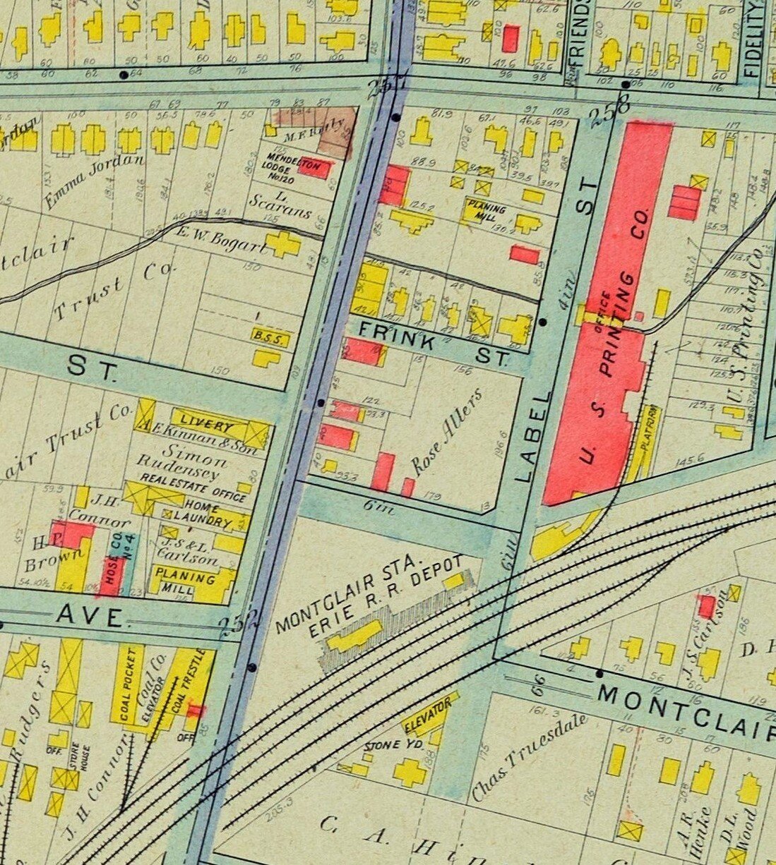
The area around the Walnut Street train station, shown as Montclair Station Depot was also industrial, with mills, coal and stone yards—and even a label factory on….Label Street!
Detail from Plate 24 1906 Essex County NJ
Maple Avenue School would become Glenfield School. Glenfield Park, the 19-acre, Olmsted-designed Essex County Park, would not be constructed east and south of the school until 1910.
Detail from Plate 24 1906 Essex County NJ Atlas
Plate 25 is centered approximately on Watchung Avenue, extending south to Chestnut Street and north to Bellevue Avenue; the eastern and western edges of this map extend to Verona and Glen Ridge/Bloomfield, respectively.
Large swaths of undeveloped land owned by developers such as Montclair Realty, Montclair Holding Company, C. F. Hinck, and others would soon become the residential neighborhoods we recognize today.
Today’s Watchung Avenue train station was called Park Street Station.
Edgemont Park was not yet created in 1906, but its earlier life as a golf course is indicated by the “Erwin Park Golf Assn” structure near where Valley Road curves.
Detail from Plate 25 1906 Essex County NJ Atlas
As with the other train stations in town, the area around the Upper Montclair station, on the south side of Bellevue Avenue, was home to practical, industrial uses including the Osborne & Marsellis lumber, coal, and stone yard. The Olmsted-designed Anderson Park, constructed in 1903, is present, but the residential neighborhood south of the park is not yet developed.
Detail from Plate 25 1906 Essex County NJ Atlas
Plate 26 starts on the north side of Bellevue Avenue and extends to the town’s northern border with Passaic County, our western border with Verona/Cedar Grove, and eastern border with Bloomfield.
Whimsical property names on this map include “Lookout Hill,” “Homeland,” and “Bienvenu.”
“McGinness Hot Bed” is denoted on this property between the railroad tracks and Valley Road, just north of Jerome Avenue…any guesses?
Detail from Plate 26 1906 Essex County NJ Atlas
The Upper Montclair Country Club straddled the Montclair/Bloomfield line north of Bellevue Avenue along Grove Street. You can place it by locating today’s streets with names such as “Club Road,” “Greenview Way,” and “The Fairway.”
Montclair’s location on the eastern slope of First Mountain, part of the Watchung Mountain chain, lent itself to quarry operations. The Osborne & Marsellis Stone Quarry is seen above Bradford Avenue (misspelled as Brandford) along a truncated Highland Avenue. The quarry operated from 1890-1918. Note property owner Benjamin Moore, whose name is seen on multiple lots near Bradford Ave; yes, it is the paint manufacturer.
Detail from Plate 26 1906 Essex County NJ Atlas
All of the above maps can be viewed in high detail on our digital collections web site. Head directly to our digital collections and browse by ‘Maps,’ or follow any of the links below for a closer look at each map plate.
The Montclair History Center has a collection of tax maps, Sanborn Insurance maps, and atlases from a variety of years. If you would like to purchase a replica of one of our maps, please visit our store.


